Pluto’s big moon Charon reveals a colourful & violent history

NASA/Johns Hopkins University Applied Physics Laboratory/Southwest Research Institute Press Release

NASA's New Horizons captured this high-resolution enhanced colour view of Charon just before closest approach on 14 July 2015 and transmitted to Earth on 21 September. The image combines blue, red and infrared images taken by the spacecraft's Ralph/Multispectral Visual Imaging Camera (MVIC); the colours are processed to best highlight the variation of surface properties across Charon. Charon's colour palette is not as diverse as Pluto's; most striking is the reddish north (top) polar region, informally named Mordor Macula. Charon is 754 miles (1,214 kilometres) across; this image resolves details as small as 1.8 miles (2.9 kilometres). Image credit: NASA/Johns Hopkins University Applied Physics Laboratory/Southwest Research Institute.
NASA’s New Horizons captured this high-resolution enhanced colour view of Charon just before closest approach on 14 July 2015 and transmitted to Earth on 21 September (click to see full size). The image combines blue, red and infrared images taken by the spacecraft’s Ralph/Multispectral Visual Imaging Camera (MVIC); the colours are processed to best highlight the variation of surface properties across Charon. Charon’s colour palette is not as diverse as Pluto’s; most striking is the reddish north (top) polar region, informally named Mordor Macula. Charon is 754 miles (1,214 kilometres) across; this image resolves details as small as 1.8 miles (2.9 kilometres). Image credit: NASA/Johns Hopkins University Applied Physics Laboratory/Southwest Research Institute.
NASA’s New Horizons spacecraft has returned the best colour and the highest resolution images yet of Pluto’s largest moon, Charon — and these pictures show a surprisingly complex and violent history.

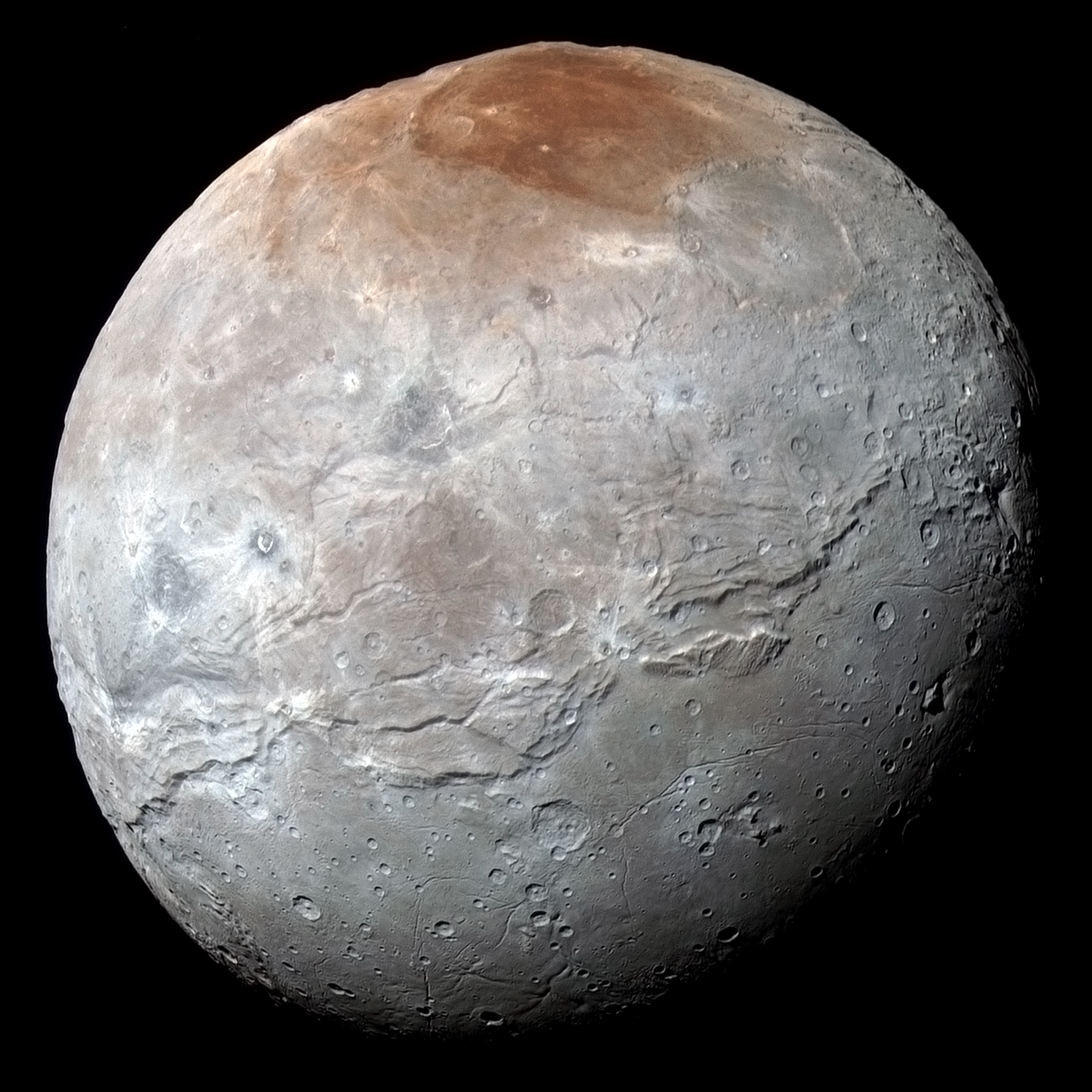
At half the diameter of Pluto, Charon is the largest satellite relative to its planet in the solar system. Many New Horizons scientists expected Charon to be a monotonous, crater-battered world; instead, they’re finding a landscape covered with mountains, canyons, landslides, surface-colour variations and more.

“We thought the probability of seeing such interesting features on this satellite of a world at the far edge of our solar system was low,” said Ross Beyer, an affiliate of the New Horizons Geology, Geophysics and Imaging (GGI) team from the SETI Institute and NASA Ames Research Center in Mountain View, California, “but I couldn’t be more delighted with what we see!”

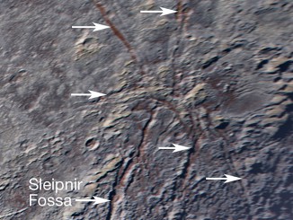
High-resolution images of the Pluto-facing hemisphere of Charon, taken by New Horizons as the spacecraft sped through the Pluto system on 14 July, and transmitted to Earth on 21 September, reveal details of a belt of fractures and canyons just north of the moon’s equator. This great canyon system stretches across the entire face of Charon, more than a thousand miles, and probably around onto Charon’s far side. Four times as long as the Grand Canyon, and twice as deep in places, these faults and canyons indicate a titanic geological upheaval in Charon’s past.

High-resolution images of Charon were taken by the Long Range Reconnaissance Imager (LORRI) on NASA's New Horizons spacecraft, shortly before closest approach on 14 July 2015, and overlaid with enhanced colour from the Ralph/Multispectral Visual Imaging Camera (MVIC). Charon's cratered uplands at the right are broken by series of canyons, and replaced on the left (south) by the rolling plains of the informally named Vulcan Planum. The scene covers Charon’s width of 754 miles (1,214 kilometres) and resolves details as small as 0.5 miles (0.8 kilometres). North is to the right. (Click to view full-size picture). Image credit: NASA/Johns Hopkins University Applied Physics Laboratory/Southwest Research Institute.
High-resolution images of Charon were taken by the Long Range Reconnaissance Imager (LORRI) on NASA’s New Horizons spacecraft, shortly before closest approach on 14 July 2015, and overlaid with enhanced colour from the Ralph/Multispectral Visual Imaging Camera (MVIC). Charon’s cratered uplands at the right are broken by series of canyons, and replaced on the left (south) by the rolling plains of the informally named Vulcan Planum. The scene covers Charon’s width of 754 miles (1,214 kilometres) and resolves details as small as 0.5 miles (0.8 kilometres). North is to the right. Click to view full-size picture. Image credit: NASA/Johns Hopkins University Applied Physics Laboratory/Southwest Research Institute.
“It looks like the entire crust of Charon has been split open,” said John Spencer, deputy lead for GGI at the Southwest Research Institute in Boulder, Colorado. “In respect to its size relative to Charon, this feature is much like the vast Valles Marineris canyon system on Mars.”

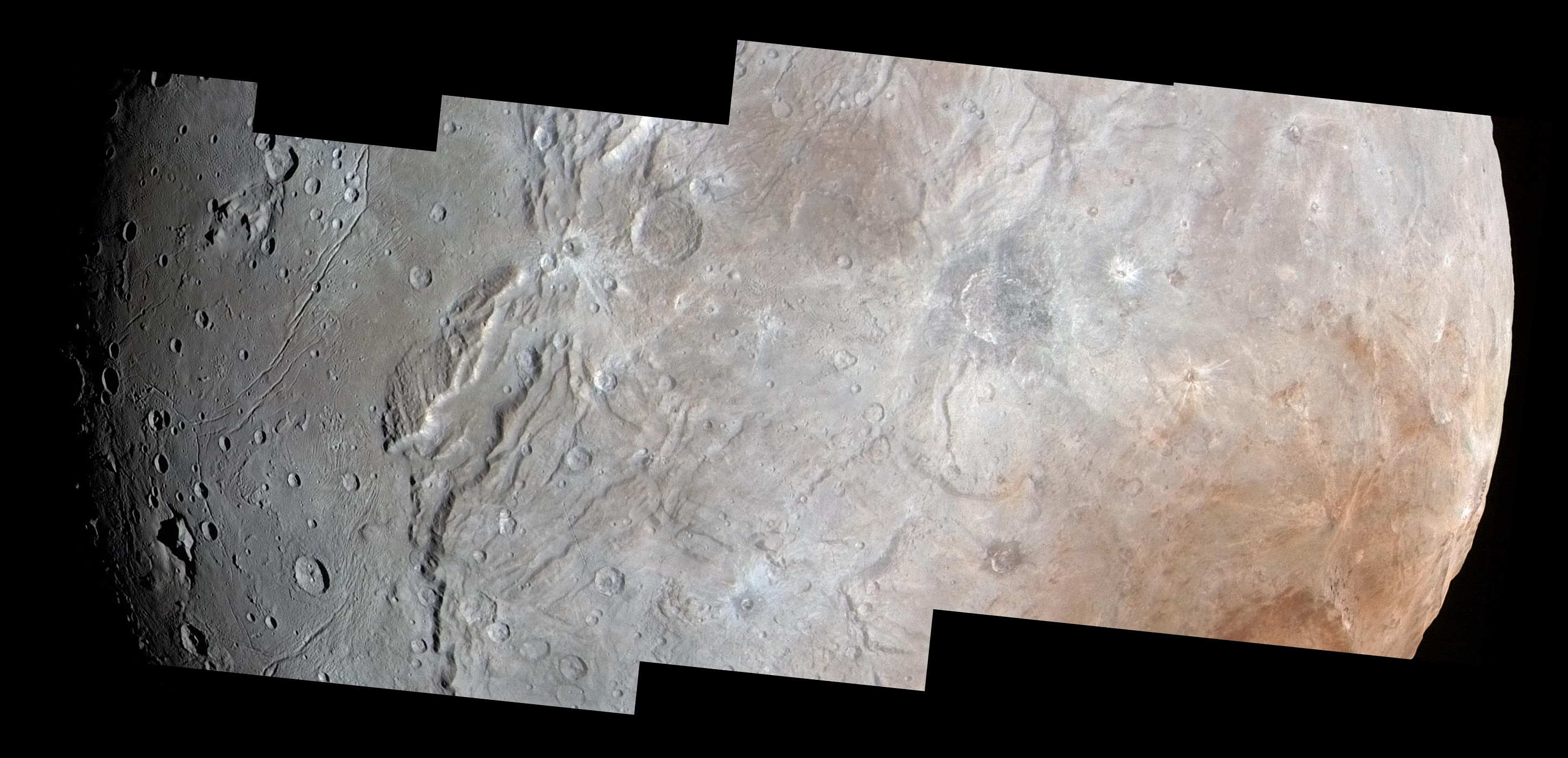
The team has also discovered that the plains south of the canyon, informally referred to as Vulcan Planum, have fewer large craters than the regions to the north, indicating that they are noticeably younger. The smoothness of the plains, as well as their grooves and faint ridges, are clear signs of wide-scale resurfacing.

One possibility for the smooth surface is a kind of cold volcanic activity, called cryovolcanism. “The team is discussing the possibility that an internal water ocean could have frozen long ago, and the resulting volume change could have led to Charon cracking open, allowing water-based lavas to reach the surface at that time,” said Paul Schenk, a New Horizons team member from the Lunar and Planetary Institute in Houston.

Even higher-resolution Charon images and composition data are still to come as New Horizons transmits data, stored on its digital recorders, over the next year — and as that happens, “I predict Charon’s story will become even more amazing!” said mission Project Scientist Hal Weaver, of the Johns Hopkins University Applied Physics Laboratory in Laurel, Maryland.

The New Horizons spacecraft is currently 3.1 billion miles (5 billion kilometres) from Earth, with all systems healthy and operating normally.