In this highest-resolution image from NASA’s New Horizons spacecraft, great blocks of Pluto’s water-ice crust appear jammed together in the informally named al-Idrisi mountains. Some mountain sides appear coated in dark material, while other sides are bright. Several sheer faces appear to show crustal layering, perhaps related to the layers seen in some of Pluto’s crater walls. Other materials appear crushed between the mountains, as if these great blocks of water ice, some standing as much as 1.5 miles high, were jostled back and forth. The mountains end abruptly at the shoreline of the informally named Sputnik Planum, where the soft, nitrogen-rich ices of the plain form a nearly level surface, broken only by the fine trace work of striking, cellular boundaries and the textured surface of the plain’s ices (which is possibly related to sunlight-driven ice sublimation). This view is about 50 miles wide. The top of the image is to Pluto’s northwest. Image credit: NASA/JHUAPL/SwRI.NASA’s New Horizons spacecraft has sent back the first in a series of the sharpest views of Pluto it obtained during its July flyby — and the best close-ups of Pluto that humans may see for decades.
Each week the piano-sized New Horizons spacecraft transmits data stored on its digital recorders from its flight through the Pluto system on 14 July. These latest pictures are part of a sequence taken near New Horizons’ closest approach to Pluto, with resolutions of about 250-280 feet (77-85 metres) per pixel — revealing features less than half the size of a city block on Pluto’s diverse surface. In these new images, New Horizons captured a wide variety of cratered, mountainous and glacial terrains.
“These close-up images, showing the diversity of terrain on Pluto, demonstrate the power of our robotic planetary explorers to return intriguing data to scientists back here on planet Earth,” said John Grunsfeld, former astronaut and associate administrator for NASA’s Science Mission Directorate. “New Horizons thrilled us during the July flyby with the first close images of Pluto, and as the spacecraft transmits the treasure trove of images in its onboard memory back to us, we continue to be amazed by what we see.”This highest-resolution image from NASA’s New Horizons spacecraft shows how erosion and faulting has sculpted this portion of Pluto’s icy crust into rugged badlands. The prominent 1.2-mile-high cliff at the top, running from left to upper right, is part of a great canyon system that stretches for hundreds of miles across Pluto’s northern hemisphere. New Horizons team members think that the mountains in the middle are made of water ice, but have been modified by the movement of nitrogen or other exotic ice glaciers over long periods of time, resulting in a muted landscape of rounded peaks and intervening sets of short ridges. At the bottom of this 50-mile-wide image, the terrain transforms dramatically into a fractured and finely broken up floor at the northwest margin of the giant ice plain informally called Sputnik Planum. The top of the image is to Pluto’s northwest. Image credit: NASA/JHUAPL/SwRI.These latest images form a strip 50 miles (80 kilometres) wide on a world 3 billion miles away. The pictures trend from Pluto’s jagged horizon about 500 miles (800 kilometres) northwest of the informally named Sputnik Planum, across the al-Idrisi mountains, over the shoreline of Sputnik, and across its icy plains.
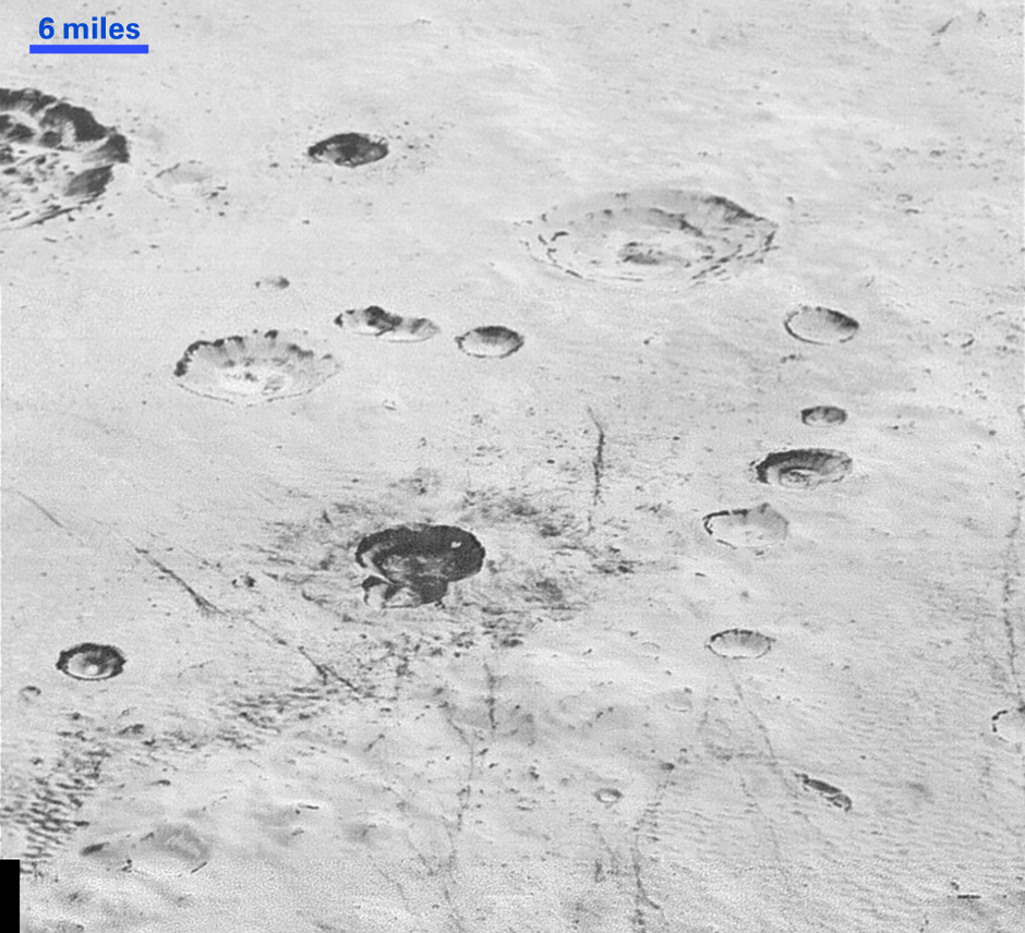
“These new images give us a breathtaking, super-high resolution window into Pluto’s geology,” said New Horizons Principal Investigator Alan Stern, of the Southwest Research Institute (SwRI) in Boulder, Colorado. “Nothing of this quality was available for Venus or Mars until decades after their first flybys; yet at Pluto we’re there already — down among the craters, mountains and ice fields — less than five months after flyby! The science we can do with these images is simply unbelievable.”This highest-resolution image from NASA’s New Horizons spacecraft reveals new details of Pluto’s rugged, icy cratered plains. Notice the layering in the interior walls of many craters (the large crater at upper right is a good example). Layers in geology usually mean an important change in composition or event, but at the moment New Horizons team members do not know if they are seeing local, regional or global layering. The darker crater in the lower center is apparently younger than the others, because dark material ejected from within — its “ejecta blanket” — has not been erased and can still be made out. The origin of the many dark linear features trending roughly vertically in the bottom half of the image is under debate, but may be tectonic. Most of the craters seen here lie within the 155-mile (250-kilometre)-wide Burney Basin, whose outer rim or ring forms the line of hills or low mountains at bottom. The basin is informally named after Venetia Burney, the English schoolgirl who first proposed the name “Pluto” for the newly discovered planet in 1930. The top of the image is to Pluto’s northwest. Image credit: NASA/JHUAPL/SwRI.The images above were captured with the telescopic Long Range Reconnaissance Imager (LORRI) aboard New Horizons, about 15 minutes before New Horizons’ closest approach to Pluto — from a range of just 10,000 miles (17,000 kilometres). They were obtained with an unusual observing mode; instead of working in the usual “point and shoot,” LORRI snapped pictures every three seconds while the Ralph/Multispectral Visual Imaging Camera (MVIC) aboard New Horizons was scanning the surface. This mode requires unusually short exposures to avoid blurring the images.
These new images are six times better than the resolution of the global Pluto map New Horizons obtained, and five times better than the best images of Pluto’s cousin Triton, Neptune’s large moon, obtained by Voyager 2 in 1989.
Mission scientists expect more imagery from this set over the next several days, showing even more terrain at this highest resolution.
Pluto is thought to possess a subsurface ocean, which is not so much a sign of water as it is a tremendous clue that other dwarf planets in deep space also may contain similarly exotic oceans, naturally leading to the question of life, said one co-investigator with NASA’s New Horizon.
NASA’s New Horizons spacecraft spied extensional faults on Pluto, a sign that the dwarf planet has undergone a global expansion possibly due to the slow freezing of a sub-surface ocean. A new analysis by Brown University scientists bolsters that idea, and suggests that ocean is likely still there today.
Speeding through the outer solar system after a nine-year trek from Earth, NASA’s New Horizons spacecraft is awake and preparing for an encounter next summer with Pluto.