New names and insights at dwarf planet Ceres

NASA's Jet Propulsion Laboratory Press Release

This colour-coded map from NASA’s Dawn mission shows the highs and lows of topography on the surface of dwarf planet Ceres. The colour scale extends about 5 miles (7.5 kilometres) below the surface in indigo to 5 miles (7.5 kilometres) above the surface in white. The topographic map was constructed from analysing images from Dawn’s framing camera taken from varying Sun and viewing angles. The map was combined with an image mosaic of Ceres and projected as an simple cylindrical projection. Image credit: NASA/JPL-Caltech/UCLA/MPS/DLR/IDA.

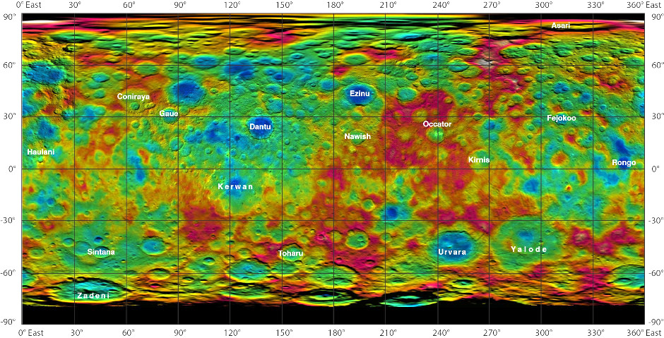
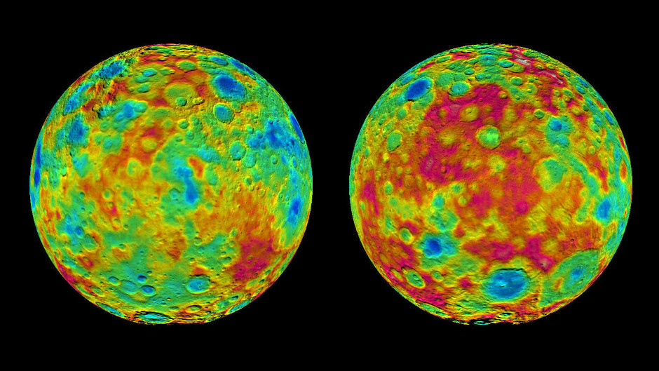
Colourful new maps of Ceres, based on data from NASA’s Dawn spacecraft, showcase a diverse topography, with height differences between crater bottoms and mountain peaks as great as 9 miles (15 kilometres).

Scientists continue to analyse the latest data from Dawn as the spacecraft makes its way to its third mapping orbit.

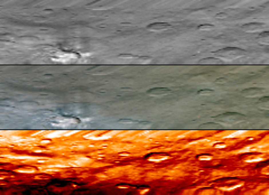
“The craters we find on Ceres, in terms of their depth and diameter, are very similar to what we see on Dione and Tethys, two icy satellites of Saturn that are about the same size and density as Ceres. The features are pretty consistent with an ice-rich crust,” said Dawn science team member Paul Schenk, a geologist at the Lunar and Planetary Institute, Houston.

Topographic maps of Ceres' east and west hemispheres. The map at left is centered on terrain at 60 degrees east longitude; the map at right is centered on 240 degrees east longitude. The colour scale extends about 5 miles (7.5 kilometers) below the surface in indigo to 5 miles (7.5 kilometers) above the surface in white. Image credit: NASA/JPL-Caltech/UCLA/MPS/DLR/IDA.
Topographic maps of Ceres’ east and west hemispheres. The map at left is centered on terrain at 60 degrees east longitude; the map at right is centered on 240 degrees east longitude. The colour scale extends about 5 miles (7.5 kilometers) below the surface in indigo to 5 miles (7.5 kilometers) above the surface in white. Image credit: NASA/JPL-Caltech/UCLA/MPS/DLR/IDA.

Some of these craters and other features now have official names, inspired by spirits and deities relating to agriculture from a variety of cultures. The International Astronomical Union recently approved a batch of names for features on Ceres.

The newly labelled features include Occator, the mysterious crater containing Ceres’ brightest spots, which has a diameter of about 60 miles (90 kilometres) and a depth of about 2 miles (4 kilometres). Occator is the name of the Roman agriculture deity of harrowing, a method of levelling soil.

A smaller crater with bright material, previously labeled “Spot 1,” is now identified as Haulani, after the Hawaiian plant goddess. Haulani has a diameter of about 20 miles (30 kilometres). Temperature data from Dawn’s visible and infrared mapping spectrometer show that this crater seems to be colder than most of the territory around it.

Dantu crater, named after the Ghanaian god associated with the planting of corn, is about 75 miles (120 kilometres) across and 3 miles (5 kilometres) deep. A crater called Ezinu, after the Sumerian goddess of grain, is about the same size. Both are less than half the size of Kerwan, named after the Hopi spirit of sprouting maize, and Yalode, a crater named after the African Dahomey goddess worshipped by women at harvest rites.

“The impact craters Dantu and Ezinu are extremely deep, while the much larger impact basins Kerwan and Yalode exhibit much shallower depth, indicating increasing ice mobility with crater size and age,” said Ralf Jaumann, a Dawn science team member at the German Aerospace Center (DLR) in Berlin.

Almost directly south of Occator is Urvara, a crater named for the Indian and Iranian deity of plants and fields. Urvara, about 100 miles (160 kilometres) wide and 3 miles (6 kilometres) deep, has a prominent central pointy peak that is 2 miles (3 kilometres) high.

This image, from NASA's Dawn's visible and infrared mapping spectrometer (VIR), highlights a bright region on Ceres known as Haulani, named after the Hawaiian plant goddess. Each row shows Ceres' surface at different wavelengths. On top is a black-and-white image; in the middle is a true-colour image, and the bottom is in thermal infrared, where brighter colours represent higher temperatures and dark colours correspond to colder temperatures. The three images appear slightly flattened in the y-axis and smeared in the upper part due to the motion of the spacecraft. These images were taken at a distance of 2,722 miles (4,381 kilometres) from Ceres and have a resolution of about 0.6 miles (1 kilometre) per pixel. They were produced on 6 June 2015. Image credit: NASA/JPL-Caltech/UCLA/ASI/INAF.
This image, from NASA’s Dawn’s visible and infrared mapping spectrometer (VIR), highlights a bright region on Ceres known as Haulani, named after the Hawaiian plant goddess. Each row shows Ceres’ surface at different wavelengths. On top is a black-and-white image; in the middle is a true-colour image, and the bottom is in thermal infrared, where brighter colours represent higher temperatures and dark colours correspond to colder temperatures. The three images appear slightly flattened in the y-axis and smeared in the upper part due to the motion of the spacecraft. These images were taken at a distance of 2,722 miles (4,381 kilometres) from Ceres and have a resolution of about 0.6 miles (1 kilometre) per pixel. They were produced on 6 June 2015. Image credit: NASA/JPL-Caltech/UCLA/ASI/INAF.

Dawn is currently spiralling toward its third science orbit, 900 miles (less than 1,500 kilometres) above the surface, or three times closer to Ceres than its previous orbit. The spacecraft will reach this orbit in mid-August and begin taking images and other data again.

Ceres, with a diameter of 584 miles (940 kilometres), is the largest object in the main asteroid belt, located between Mars and Jupiter. This makes Ceres about 40 percent the size of Pluto, another dwarf planet, which NASA’s New Horizons mission flew by earlier this month.

On 6 March 2015, Dawn made history as the first mission to reach a dwarf planet, and the first to orbit two distinct extraterrestrial targets. It conducted extensive observations of Vesta in 2011-2012.