Clicking on the graphic above loads a 1:10 scale version of the full resolution Pluto map just published based on imagery acquired by NASA’s New Horizons spacecraft 7-14 July 2015. A link to the full resolution image for high-specification desktop computers with RAM to spare is included in the article below. Image credit: NASA/Johns Hopkins University Applied Physics Laboratory/Southwest Research Institute.The science team of NASA’s New Horizons mission has produced an updated global map of the dwarf planet Pluto. The map includes all resolved images of the surface acquired 7-14 July 2015, at pixel resolutions ranging from 40 kilometres (24 miles) on the Charon-facing hemisphere (left and right sides of the map) to 400 metres (1,250 feet) on the anti-Charon facing hemisphere (map center). Many additional images are expected in autumn 2015 and these will be used to complete the global map.
The New Horizons spacecraft flew past Pluto and its moons on July 14. For high-specification desktop computers with RAM to spare, a full resolution (18630 by 9315 pixel, 5.221MB) version of the above image is available by clicking here.
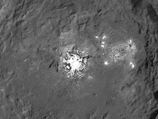
Pluto’s “icy heart” is a bright, two-lobed feature on its surface that was discovered by NASA’s New Horizons team in 2015. The heart’s western lobe, informally named Sputnik Planitia, is a deep basin generally thought to have been created by a smaller body striking Pluto at extremely high speed, but a new study suggests a different origin.
Pluto and its Texas-sized moon Charon share an alien environment on the solar system’s outer frontier, with patches of organic ices and diverse rock types illustrated in color imagery released Tuesday.
Now just five days away from its close encounter with dwarf planet Pluto, NASA’s New Horizons spacecraft beams back the first image to be received since the 4 July anomaly that sent the spacecraft into safe mode, indicating that all systems appear to be functioning normally. The flyby sequence of science observations is officially underway.