Wright Mons in colour. This composite image of a possible ice volcano on Pluto includes pictures taken by the New Horizons spacecraft’s Long Range Reconnaissance Imager (LORRI) on 14 July 2015, from a range of about 30,000 miles (48,000 kilometres), showing features as small as 1,500 feet (450 metres) across. Sprinkled across the LORRI mosaic is enhanced colour data from the Ralph/Multispectral Visible Imaging Camera (MVIC), from a range of 21,000 miles (34,000 kilometres) and at a resolution of about 2,100 feet (650 metres) per pixel. The entire scene is 140 miles (230 kilometres) across. Image credits: NASA/JHUAPL/SwRI.Scientists with NASA’s New Horizons mission have assembled this highest-resolution colour view of one of two potential cryovolcanoes spotted on the surface of Pluto by the New Horizons spacecraft in July 2015.
This feature, known as Wright Mons, was informally named by the New Horizons team in honour of the Wright brothers. At about 90 miles (150 kilometres) across and 2.5 miles (4 kilometres) high, this feature is enormous. If it is in fact a volcano, as suspected, it would be the largest such feature discovered in the outer solar system.
Mission scientists are intrigued by the sparse distribution of red material in the image and wonder why it is not more widespread. Also perplexing is that there is only one identified impact crater on Wright Mons itself, telling scientists that the surface (as well as some of the crust underneath) was created relatively recently. This is turn may indicate that Wright Mons was volcanically active late in Pluto’s history.Image credits: NASA/JHUAPL/SwRI.
In June 2015, when the cameras on NASA’s approaching New Horizons spacecraft first spotted the large reddish polar region on Pluto’s largest moon, Charon, mission scientists knew two things: they’d never seen anything like it elsewhere in our Solar System, and they couldn’t wait to get the story behind it.
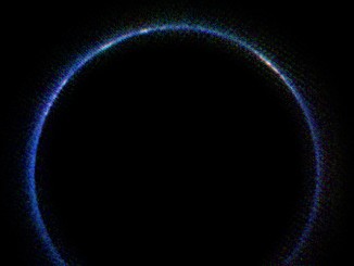
A new image from NASA’s New Horizons spacecraft is the first look at Pluto’s atmosphere in infrared wavelengths, and the first image of the atmosphere made with data from the probe’s LEISA instrument. The blue ring around Pluto is caused by sunlight scattered from a haze of hydrocarbon particles in the form of a photochemical smog.
What is the origin of the large heart-shaped nitrogen glacier on Pluto revealed by NASA’s New Horizons spacecraft in 2015? Two French researchers show that Pluto’s peculiar insolation and atmosphere favour nitrogen condensation near the equator, in the lower altitude regions, leading to an accumulation of ice at the bottom of Sputnik Planum, a vast topographic basin.