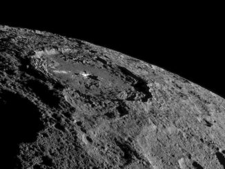
Dawn sends sharper scenes from dwarf planet Ceres

NASA's Jet Propulsion Laboratory Press Release

NASA's Dawn spacecraft spotted this tall, conical mountain on Ceres from a distance of 915 miles (1,470 kilometres). The mountain, located in the southern hemisphere, stands 4 miles (6 kilometres) high. Its perimeter is sharply defined, with almost no accumulated debris at the base of the brightly streaked slope with bright streaks. The image was taken on 19 August 2015 at a resolution of 450 feet (140 metres) per pixel. Image credit: NASA/JPL-Caltech/UCLA/MPS/DLR/IDA.
NASA’s Dawn spacecraft spotted this tall, conical mountain on Ceres from a distance of 915 miles (1,470 kilometres). The mountain, located in the southern hemisphere, stands 4 miles (6 kilometres) high. Its perimeter is sharply defined, with almost no accumulated debris at the base of the brightly streaked slope with bright streaks. The image was taken on 19 August 2015 at a resolution of 450 feet (140 metres) per pixel. Image credit: NASA/JPL-Caltech/UCLA/MPS/DLR/IDA.
The closest-yet views of Ceres, delivered by NASA’s Dawn spacecraft, show the small world’s features in unprecedented detail, including Ceres’ tall, conical mountain; crater formation features and narrow, braided fractures.

“Dawn is performing flawlessly in this new orbit as it conducts its ambitious exploration. The spacecraft’s view is now three times as sharp as in its previous mapping orbit, revealing exciting new details of this intriguing dwarf planet,” said Marc Rayman, Dawn’s chief engineer and mission director, based at NASA’s Jet Propulsion Laboratory, Pasadena, California.

At its current orbital altitude of 915 miles (1,470 kilometres), Dawn takes 11 days to capture and return images of Ceres’ whole surface. Each 11-day cycle consists of 14 orbits. Over the next two months, the spacecraft will map the entirety of Ceres six times.

A full resolution close-up of Ceres' four-mile-high "Lonely Mountain" from the image above. Image credit: NASA/JPL-Caltech/UCLA/MPS/DLR/IDA.
A full resolution close-up of Ceres’ four-mile-high “Lonely Mountain” from the picture above. Image credit: NASA/JPL-Caltech/UCLA/MPS/DLR/IDA.
The spacecraft is using its framing camera to extensively map the surface, enabling 3-D modelling. Every image from this orbit has a resolution of 450 feet (140 metres) per pixel, and covers less than one percent of the surface of Ceres.

At the same time, Dawn’s visible and infrared mapping spectrometer is collecting data that will give scientists a better understanding of the minerals found on Ceres’ surface.

Engineers and scientists will also refine their measurements of Ceres’ gravity field, which will help mission planners in designing Dawn’s next orbit — its lowest — as well as the journey to get there. In late October, Dawn will begin spiraling toward this final orbit, which will be at an altitude of 230 miles (375 kilometres).

Dawn is the first mission to visit a dwarf planet, and the first to orbit two distinct solar system targets. It orbited protoplanet Vesta for 14 months in 2011 and 2012, and arrived at Ceres on 6 March 2015.