
|
|
|
|
|
|
Posted: September 29, 2008 Although the SMART-1 spacecraft was buried in the graveyard of lunar regolith over two years ago, new three-dimensional images taken by the AMIE camera of the so-called ‘peak of eternal light’ have just been released by ESA.
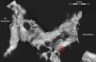
A mosaic of the lunar south pole showing possible landing sites (numbered). The peak of eternal light is marked in red. Image: P. J. Stoke. The breath-taking images were presented by Dr Detlef Koschny on the last day of the European Planetary Science Congress meeting last week. The images taken by the AMIE camera (Advanced Moon micro-Imager Experiment) were used to create digital elevation models of the terrain at the south pole, in particular around areas which are almost continuously exposed to sunlight, and therefore of most interest to scientists hoping to see future lunar bases operating on solar power. “AMIE is not a stereo camera, so producing a 3-D model of the surface has been a challenge,” says Koschny. “We’ve used a technique where we use the brightness of reflected light to determine the slope and, by comparing several images, put together a model that produces a shadow pattern that matches those observed by SMART-1.” AMIE took a total of 113 images of the peak located close to the rim of the Shackleton Crater, which lies on the lunar south pole. In all but four of the images, the peak was illuminated by sunlight. In direct contrast, other craters at the south pole are in constant darkness and may hold water ice deposited over millions of years by cometary impacts. These permanently shadowed regions could offer a potential water supply that would also provide a vital resource for any lunar base. Looking for water ice at the south pole is one of the main goals of the LCROSS mission to be launched next year (for more on LCROSS see our news story Water-seeking Moon spacecraft passes major pre-flight tests).
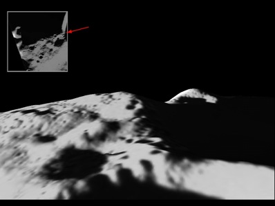
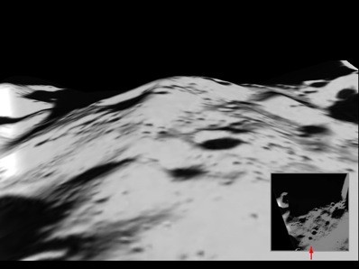
Top: The peak of eternal light as viewed from the rim of Shackleton Crater. The peak is along the ridge in the centre of the image. Bottom: The peak of eternal light with Shackleton Crater just off the image to the right, and landing site 4 on the left hand side of the peak. Images: ESA/SMART-1/SPACE-X (Space Exploration Institute). In the images shown here, the peak of eternal light is illuminated from different angles. The science team mapped all the image pixels onto a grid (the resolution of the AMIE images is about 50 metres per pixel), defining the bright and dark areas accordingly. The data from the images were then compared to produce estimates of the slope angles, and the digital elevation model was matched to the shadows seen in the images. The original AMIE images were then projected onto the model. In order to visualise the topography, the elevation has been exaggerated five times. |
|
|
|
||||||||||||||||||||||||||||||||||||||||||