
|
|
|
|
|
|
Posted: August 13, 2008 The images from Cassini’s latest maneuver around icy Enceladus are already back in terrestrial hands in what is said to be a “dazzling success” by Cassini Imaging Team Leader Carolyn Porco. “As you gaze at these awesome sights, seen for the first time here and now, in exquisite detail, I ask you: Is there anything more thrilling, more stimulating to the mind, more gratifying to the soul than exploring new worlds?!” she says.
Map of the south polar region of Enceladus showing the seven 'skeet shoot' footprints (green boxes). The imaging track cuts across the main tiger stripes, or sulci, and includes the locations of several active eruption sites observed in previous flybys (red spots). Image: NASA/JPL/Space Science Institute. Yesterday we reported on Cassini’s Monday 11 August flyby of Enceladus (Cassini swoops past Enceladus), and just two days later, images from the high resolution imaging sequence are safely in the hands of the Cassini Imaging Team. The images show the south polar terrain in unprecedented detail, including close up views of several of the enigmatic tiger stripe fractures, or sulci as they are more formally identified, that are known to host local hot spots and the sites of previously observed eruptions.
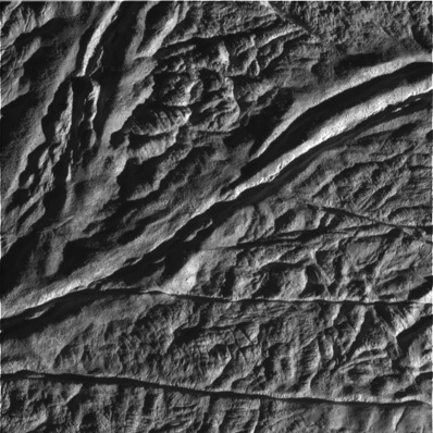
Skeet 4: Cairo Sulcus is shown crossing the upper left portion of the image. An unnamed fracture curves around the lower right corner. The image was taken at a distance of approximately 2,621 kilometres above the surface of Enceladus. Image scale is approximately 20 metres per pixel. Image: NASA/JPL/Space Science Institute. The images are a photographic triumph, since they were taken with the camera shutter open, travelling at 18 kilometres per second (40,000 miles per hour), in what has been nicknamed the ‘skeet-shoot’ technique in honour of the current Olympic games skeet event, and especially since the spacecraft was shooting rapidly at Enceladus’ surface with a multitude of scientific instruments and cameras. To put the achievement into context, the feat was equivalent to capturing a sharp, unsmeared picture of a roadside billboard from a distance of one mile with a 2,000 millimetre telephoto lens held out of a window of a car moving at 50 miles per hour. This accomplished stunt was executed by programing the Cassini spacecraft to track a point in space while it waited for Enceladus to move into the camera’s field of view. Once the south polar region was in the line of fire, the camera shot in rapid succession several high priority targets at resolutions of 8 to 28 metres per pixel.
Skeet 5: This image was taken at a distance of approximately 3,600 kilometres above the surface of Enceladus and cuts across Baghdad Suclus. Image scale is approximately 24 metres per pixel. Image: NASA/JPL/Space Science Institute.
Skeet 7: Damascus Sulcus is crossing the upper part of the image. The image was taken at a distance of approximately 4,742 kilometres above the surface of Enceladus. Image scale is approximately 30 metres per pixel. Image: NASA/JPL/Space Science Institute. In addition to the skeet-shoot sequence, Cassini also acquired mosaics of the south polar region and the northern cratered plains, as well as using the rest of the optical remote sensing instruments to make various measurements of the local geology and icy plumes emanating from the tiger stripes in infrared, visible and ultraviolet wavelengths. For more images and details about the latest Enceladus flyby see: http://ciclops.org
Related Stories
Aug 12 Cassini swoops past Enceladus read more Jun 02 Cassini primed for extended tour of Saturn read more May 21 Cassini maps of Saturn’s moons... read more Mar 27 Cassini tastes organic material... read more Mar 14 Cassini flyby success read more Mar 11 Cassini to dive into water plume... read more |
|
|
|
||||||||||||||||||||||||||||||||||||||||||