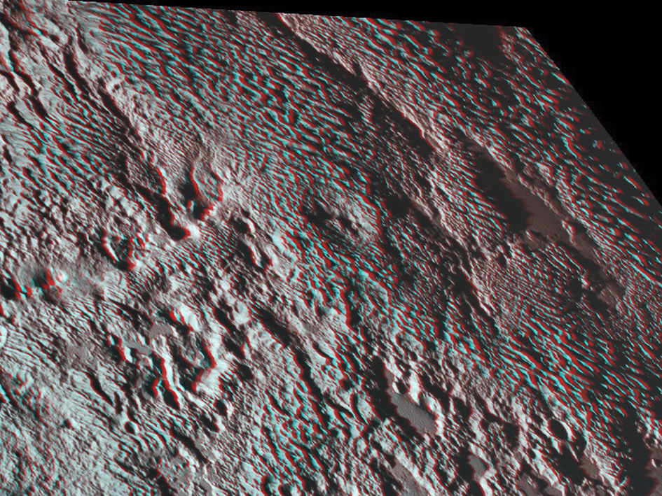
Grab your red and green 3-D spectacles to fully appreciate New Horizons’ view of the “bladed” terrain just east of Tombaugh Regio, the informal name given to Pluto’s large heart-shaped surface feature. Formally named Tartarus Dorsa, they align from north to south, reach hundreds of feet high and are typically spaced a few miles apart. Click the image for a full-size version. Image credits: NASA/JHUAPL/SwRI.One of the strangest landforms spotted by NASA’s New Horizons spacecraft when it flew past Pluto last July was the “bladed” terrain just east of Tombaugh Regio, the informal name given to Pluto’s large heart-shaped surface feature.
No geology degree is necessary to see why the terrain is so interesting. Formally named Tartarus Dorsa, they align from north to south, reach hundreds of feet high and are typically spaced a few miles apart. This remarkable landform, unlike any other seen in our solar system, is perched on a much broader set of rounded ridges that are separated by flat valley floors.
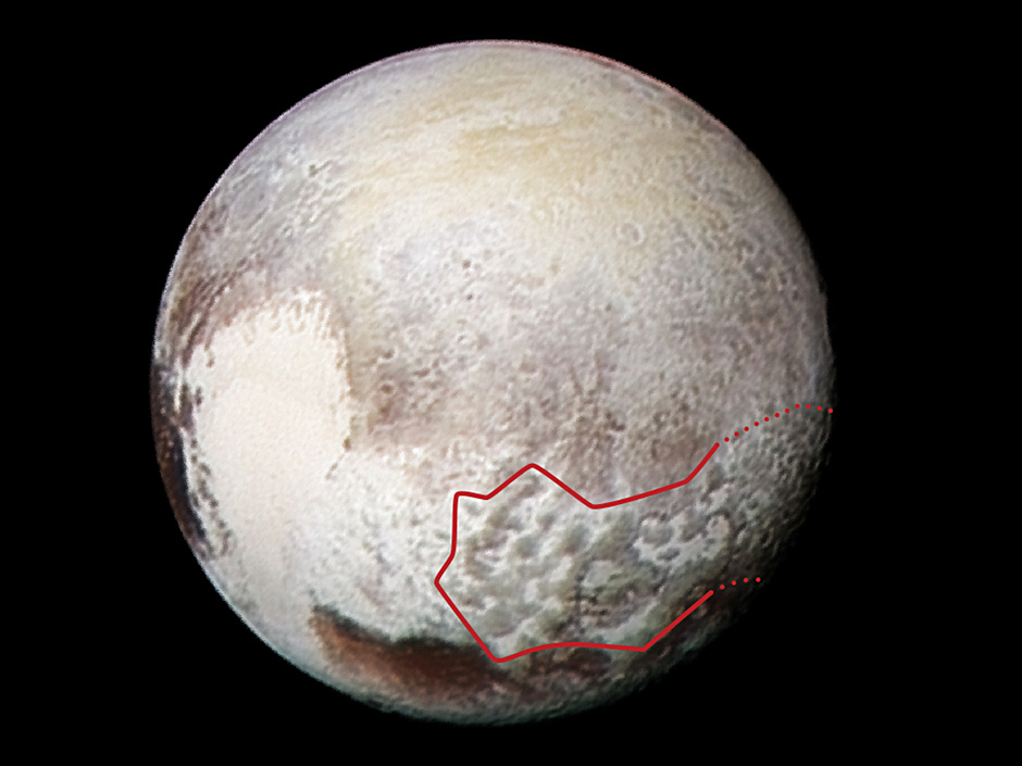
On the global image below, the bladed terrain extends far to the east. New Horizons scientists have speculated about (but not yet agreed on) the terrain’s origins. Current theories include erosion from evaporating ices or deposition of methane ices; New Horizons researcher Orkan Umurhan takes an in-depth look at the terrain — and proposes another origin idea — in this recent NASA Web blog.
The amazing stereo view combines two images from the Ralph/Multispectral Visible Imaging Camera (MVIC) taken about 14 minutes apart on 14 July 2015. The first was taken when New Horizons was 16,000 miles (25,000 kilometres) away from Pluto, the second when the spacecraft was 10,000 miles (about 17,000 kilometres) away. Best resolution is approximately 1,000 feet (310 metres).
Global view Image credits: NASA/JHUAPL/SwRI.This global view of Pluto combines a Ralph/Multispectral Visible Imaging Camera (MVIC) colour scan and an image from the Long Range Reconnaissance Imager (LORRI), both obtained on 13 July 2015 — the day before New Horizons’ closest approach. The MVIC scan was taken from a range of 1 million miles (1.6 million kilometres), at a resolution of 20 miles (32 kilometres) per pixel. The corresponding LORRI image was obtained from roughly the same range, but has a higher spatial resolution of 5 miles (8 kilometres) per pixel. The red outline marks the large area of mysterious, bladed terrain extending from the eastern section of the large feature informally named Tombaugh Regio.
On 4 July, NASA will fly a solar-powered spacecraft the size of a basketball court within 2,900 miles of the cloud tops of our solar system’s largest planet, Jupiter. Over the past two weeks, several milestones occurred that were key to a successful 35-minute burn of its rocket motor, which will place the robotic explorer into a polar orbit around the gas giant.
When Pluto was reclassified as a dwarf planet in 2006, Neptune regained the title of the solar system’s outermost planet. Since this fascinating gas giant reached opposition on 1 September in the constellation Aquarius, now is a great time to seek it out. We show you how to locate Neptune with binoculars and small telescopes.
Making its fifth science pass close to Jupiter’s turbulent cloud tops, NASA’s Juno spacecraft sailed by the Solar System’s king planet Friday to collect another treasure trove of data on the giant world’s atmosphere, internal structure, and magnetic field.