
|
|
|
|
|
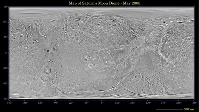
The Cassini Imaging Team has released to the public and scientific community a detailed atlas of Saturn’s tiny fractured moon Dione, the third in a series of atlases charting the enigmatic terrain of Saturn’s icy denizens. The 449 existing high-resolution Cassini images were carefully crafted together to create a single global map of Dione. The map was then divided into 15 pieces, with each piece produced at a scale of 1:1,000,000, that is, where 1 centimetre on the map equals 1 million centimetres – 10 kilometres – on the surface of the satellite.
This global map of Saturn's moon Dione was created using images taken during Cassini spacecraft flybys, with Voyager images filling in the gaps. The map is a simple cylindrical projection and has a scale of 614 metres per pixel at the equator. Image: NASA/JPL/Space Science Institute. So far in Cassini's mission, the north polar regions of Dione and the other moons of Saturn, as well as the planet itself, have remained shrouded in seasonal darkness due to Saturn’s lengthy 30 year journey around the Sun. Fortunately, the Cassini Imaging Team were able to combine some of the Cassini images with lower resolution images taken by the Voyager spacecraft in 1981. “As the Cassini mission continues, higher northern latitudes will come into sunlight, and Cassini maps should continue to improve,” says Dr Thomas Roatsch from the Institute of Planetary Research at the German Aerospace Center. It is important for planetary scientists to have accurate maps of the worlds they study because they serve as the basis for geologic interpretations, such as estimating of the ages of surface regions and deciphering the processes that formed the moons' landscapes. Most importantly, with their accurate reckoning in latitude and longitude, the maps allow scientists to easily find and refer to features of interest on the moons' surfaces. "These maps will help the team members in their scientific and mission planning efforts a great deal," says Dr Gerhard Neukum of Freie Universitat in Berlin. "It will be a reliable reference for future applications by the planetary science community at large."
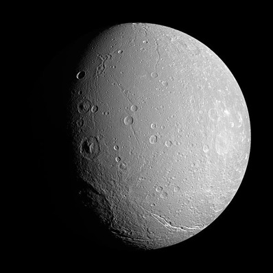
Dione is 1,125 kilometres wide and, like many of Saturn's icy satellites, has as extensive system of icy cliffs and deep fractures running across the surface. Image: NASA. "Cassini's exploration of these bodies leaves a glorious and important legacy for generations to come,” adds Carolyn Porco, Cassini imaging team leader. “Both robotic and human travelers to Saturn in the future will surely rely on this growing collection of maps to find their way among the moons of Saturn." Atlases for Enceladus and Phoebe already exist; Iapetus and Thethys are next in line. All maps and atlases are available from: http://ciclops.org, http://www.nasa.gov/cassini and http://saturn.jpl.nasa.gov.
|
|
|
|
||||||||||||||||||||||